Monday, April 17, 2017

Day 28 - Anchoring in the Rain

Current Position: 35° 12' 36" N  76° 35' 28" W

A fairly quiet day after the busyness of yesterday.  We left Beaufort shortly after 8, went under a drawbridge, down a long cut and river that was very peaceful before entering Pamlico Sound.  There the fun began as we were tossed amongst the 2-3 foot swells.  I had already been down to fix us lunch earlier, thank goodness as it wasn’t safe to move about the boat during that hour and a half.  Not bad, just not comfortable.  We both built some arm muscles holding on.  As soon as we turned toward Pamlico River the swells were coming from our aft corner and became much more manageable.  After we entered the river things quieted down again.  We are alone in our anchorage tonight with lots of “swing” room.  It’s going to be a quiet night. 
For your viewing pleasure, today we have, once again the changing scenery – now we have forests coming right down to the water.  They looked very inviting to take a stroll through as the undergrowth was not dense. 


There were some pretty houses, of course, along the cut (hey – I gave you a break yesterday from houses, so bear with me, I happen to like them :P)

Such a different style!

I love the colors!

Another usual style!


We saw more eagles nesting but couldn’t get a clear picture.  We did see this great duck blind.  Neat!


Once we entered the sound we were mostly alone on the water so were quite surprised to find a traffic jam out in the middle – with four boats going four different directions but meeting at one point in a huge sound!
(We are the 4th) this is before it got rough!

Isn't she pretty?


It only rained for about 10 minutes today – just as I was dropping the anchor!  Can’t complain though – it’s the first time I’ve had to drop it in the rain.  I’ll take rain over wind any day!


Anchored in Gale Creek just off Bay River.

Saturday, April 15, 2017

Day 27 - How to Fill a Day

Current Position: 34° 42' 54" N  76° 39' 59" W

How do we ever fit so much into one day????

1. Dinghy over to Beaufort City Dock - (free) and lock up the boat - still a little nervous of leaving her alone.

2. Walk along Front Street - the Historic District.  Houses built between 1711 and 1771.  All black and white.


3.  Visit the Historic Cemetery.  So many different grave styles. I love reading the stories on the stones that are still legible.


It's hard to tell from the picture but this is a curved cement covering over the grave. 


This one is like a picture frame

4. Stop at the Beaufort Docks and meet several fellow Loopers.  One invited us to use their internet to download the files Bob thought would fix our chart plotter as our internet signal was too weak.  While we waited for the files to download they made some great suggestions on places to visit and anchor along the route.  So much great information.

5.  Visit the free Maritime Museum and learn about:
      a.Blackbeard the Pirate, who used Beaufort as his rest and relaxation port.before he was captured and beheaded.
A model of his ship QAR - Queen Anne's Revenge

    b. Whales - Their hearts are HUGE:
  
    c.  Rescuing people from shipwrecks.  How brave the rescuers had to be.
 They would shoot the line from the shore to the wreck with a gun, then attach the life car or breeches buoy and haul the people ashore.  All this usually in the dark of a stormy night.
This is the breeches buoy - you put in on like a pair of breeches (pants) and then go zip lining.  Not the most fun thing to do in the middle of a stormy night but better than the life car, I think!
 The life car can hold 5-6 people all lying down.  They are shut into the car - total darkness and are pulled through the rolling surf to shore.  They are tossed around like rag dolls and I'm sure the stench from the ensuing illness is intolerable!

6. Stop for a quick lunch.

7. Walk through an art gallery for local artists.

8. Go back to boat so Gail can write her blog post and Bob can test the chart plotter - IT WORKED!!!  Yippee!

Notes from Bob: Nautical charts are great for trips in open water - or even in large bodies of water like the Puget Sound. However, for narrow bodies of water like the Atlantic Intracoastal Waterway, the charts just don't provide enough detail. Below is the chart for a section of the ICW:


Below is part of the same section of the ICW. Notice where the ICW goes from fairly deep (about 10') from almost bank to bank, to a very narrow deep channel (in white) with shallow water (in blue) outside of the narrow channel. That is the extra details that I missed when our chart plotters weren't correctly displaying the chart information!!


9. Wait out a little rain storm then take the dinghy over to the island next to us that is a nature reserve with a wonderful nature trail.  A little on the muddy side occasionally, but interesting.  We saw 3 wild horses and thousands of Fiddler Crabs!  It looked like the ground was moving sometimes!


Here is our boat from the island - can you find her?

10.  Back the boat, pull up the dinghy, work on the blog posts.  We are still too full from lunch so just a light snack will do for dinner.  

Good night!

Anchored in Taylor Creek, Beaufort, NC

Friday, April 14, 2017

Day 26 - Reminiscing on My Great Uncle Roy Viele

Current Position: 34° 42' 54" N  76° 39' 59" W

Floating down the ICW today, the water was so clear and calm I was transported back in time to my Great Uncle Roy Viele (my Dad's uncle).  He was a photographer, amature archeologist and collector extraodinaire. He loved seeing pictures in nature, whether it be the bark of a tree or reflections in the water.  He loved to photograph the reflections and then turn them sideways.  He would have loved our trip today and the lovely digital cameras that make taking pictures so much easier.  

 This:

Becomes this:

This is my favorite:

We started out the morning in our now quiet bay.


After a thrilling, but noisy, evening of this - a V-22 Osprey, going round, and round, and round and round....................


The ICW was smooth and quiet as well, thank goodness, because we spent most of the day on the Bogue Sound which was VERY wide and could be a little rough in windy weather.


We passed the Marine's practice area - sometimes this area is closed due to live round firings.

 There were several tanks around and profiles for target practice.

Yesterday we followed a sailboat all day...today a sailboat followed us! (not the same one. This one is French! They were anchored with us last night)  I love this picture of them going under the bridge.

As we got closer to town, the houses were as prominent on the west side as the salt marshes were on the east.  This is a panoramic video as we neared Morehead city, taken from our flybridge. You can see the sailboat still following.  They did not anchor with us this time though.


As we approached Beaufort, NC (Bow-fert - not Byoo-fort as it was in SC) pleasure boating, fishing, tour boats, and water taxis became quite numerous.  

The little one in pink is a baby!  Thought of April and Jonathon taking their kids out at a very young age.  Starting them out right :)


Meanwhile we still see a few working boats around.  This is what a shrimp boat looks like docked. (Remember the one with his "wings" out the other day?)


This is our anchorage for the next two nights:
It's the most boats we've seen in one spot except the marina!  Most of these boat "live" here, although I don't think people live on them.

Tomorrow we meet fellow loopers and enjoy the town of Beaufort.

Meanwhile I'll close with my favorite houses of the day :)


This one is one of the few totally on stilts.  Most have at least a storage room on the ground.

This one looks like they added on the tower as an afterthought.  It even has "corner stones" Quite impressive.

My favorite of the day - so colorful.

Anchored in Taylor Creek, Beaufort, NC


Wednesday, April 12, 2017

Day 25 - How To Navigate Without a Chart Plotter

Current Position: 34° 33' 4" N  77° 19' 28" W

From a calm, beautiful start to the morning, to some interesting turns.  
Our anchorage this morning

We left our pretty anchorage and went under the bridge on our route north.  We have a 20' foot air draft and the bridge is listed at 21'.  A little close, so we called the bridge and he said 22', and the tide board read 23'.  Since we just missed the opening and would have to wait for the next one, we decided to go for it.  We made it with room to spare!  (Not much though) :)  


We quickly discovered that our chart plotter was not working.  This is the instrument that shows the water ways, depth, route plan etc.  Our route was there and depth directly under us but all the surrounding water, land, depth were missing or wrong.  I took over steering while Bob went below to work on the problem.  It's not fixed but we were able to use the computer to substitute and with both of us working together, we are able to get where we need to be safely.  We'll probably have to wait until New Bern and a week and a half to talk to someone at West Marine, but will keep looking at the issue whenever we're in a town and have internet connection.

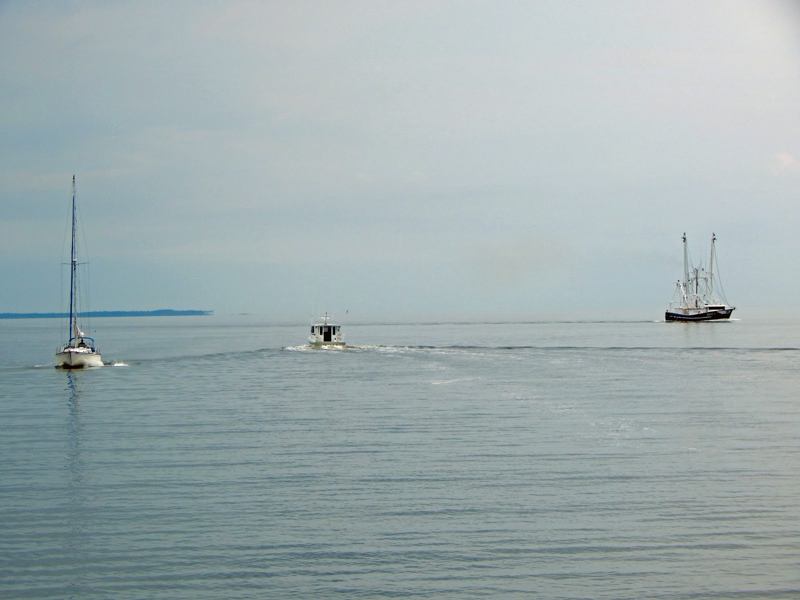
The "next bridge to cross" was another swing bridge.  This one only had a 12' clearance so we had to have it opened.  It only opens on the hour and we were going to be about 10 minutes too late.  It's a pain to hang around a bridge waiting for it to open or finding a short term anchorage, but when you gotta do it, you gotta do it - except when there are so many boats going through the bridge stays open longer!  5 boats going north and one coming south was all it took to let us squeeze through!  YAY!!  Our flotilla of 6 boats stayed together for quite a distance before the speedier ones pulled ahead leaving only the sailboat in front. 


 It was the same sailboat we shared an anchorage with last night and low and behold, they chose the same anchorage as we did tonight!  But I jumped ahead of our interesting day....

While we were following said sailboat through a very shallow area, the poor sailboat started to run aground.  Luckily they were able to get off of it before they were stuck.  We made sure we steered clear of THAT area.  Meanwhile, another trawler came up behind us and passed us, not a wise move in such a shallow area, and promptly ran aground themselves!  We went back around them and were glad to see they were able to back off the shoal.  It is common courtesy to radio the boat you plan to pass, but we had received no such message before they passed us.  Later, when they WERE in a safe passing area, they did hale us and apologized for the earlier pass as they had their radio on the wrong channel.  They must have been frustrated when we didn't answer.  So glad they got it figured out without too much difficulty.

The rest of the trip was peaceful and pretty, changing scenery again as the shoreline has more bushes and trees again, and much of the low lying islands are dry, instead of salt marsh.


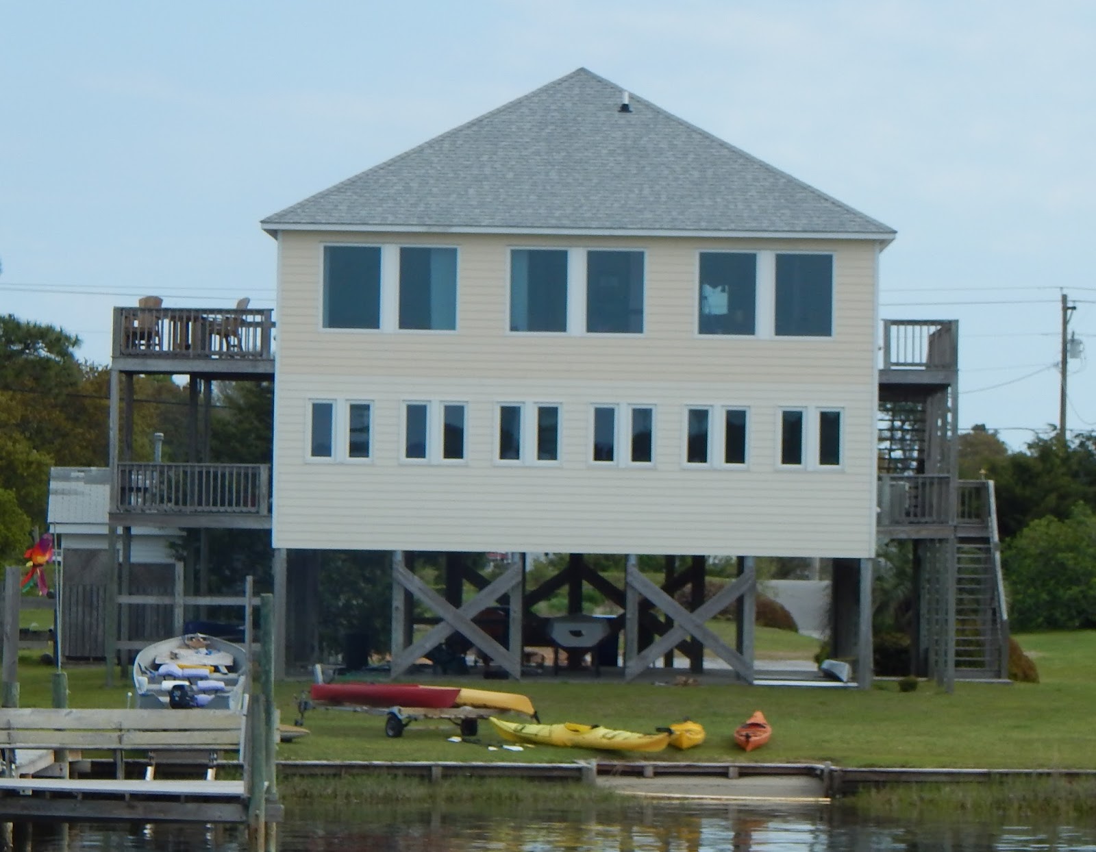
It's fun seeing all the houses along the barrier islands to our right.  


And of course there are always my favorite houses of the day:

Many on stilts:


What a statement these houses make!  The big one can afford lots of waterfront but the narrow one, although a small footprint, is still on the water!


And then of course I can't leave out the birds...not so many pelicans but now we see Hawks!


Crab boats are another daily enjoyment
 

This is our peaceful anchorage for tonight...
 Our neighbors we followed here:
 And our neighbors that make it not so peaceful - Camp Lejeune - jet fighters, helicopters, and V-22 Osprey.  At least they should quiet down this evening. The bay we're anchored in is an area maintained by the Marines where they can do amphibious warfare related tasks (like loading amphibious ships from shore).

Anchorage at Mile Hammock Bay - Camp Lejeune.